Navigate like Never Before: New AI Features Unveiled in Google Maps Update
TechSunday, 29 October 2023 at 05:00
Google Maps has been with us for a couple of years now. The navigation system for Google has made it a lot easier to navigate our ways around the world in recent years. Thanks to Google Maps, we can even locate places such as restaurants, hotels, gas stations and many more. It doesn't end there, as the search engine giant is always at work to include more features for even better navigations. recently, it added useful features like finding eco-friendly routes to save energy and using Live View to help you find your way while walking with augmented reality.
The latest in Google Maps also rides on the power of Artificial Intelligence. Google has announced that these updates will help you better plan your trips, make eco-friendly choices, and give you quick ideas for fun activities. Let us take a closer look at these new AI-powered features available to Google Maps.
Immersive View for Routes in Google Maps
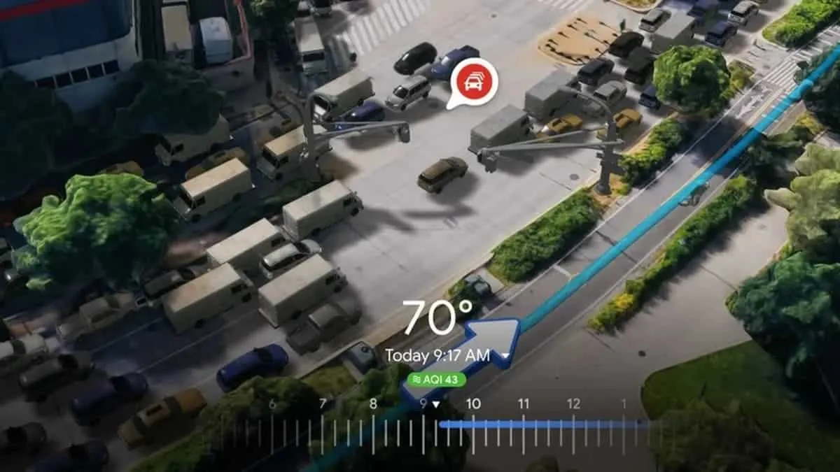
At I/O, Google introduced a new feature called Immersive View for routes. It's a unique way to see your entire journey, whether you're driving, walking, or biking. The company has already started to roll out Immersive View for routes in various cities, like Amsterdam, Barcelona, Dublin, and more.
Let's say you want to bike to the Palace of Fine Arts in San Francisco. You can ask for biking directions and then tap the Immersive View to see your route in a stunning 3D view from start to finish. You can also use the time slider to decide when to leave based on traffic and weather information. This way, you can avoid riding in the rain or heavy traffic.
According to Google, the feature is not just for routes; it can also be used for exploring places. It uses AI to combine lots of Street View and aerial images. This helps you to see what a restaurant or landmark looks like before you visit. Developers can also create their own immersive experiences with Photorealistic 3D Tiles in Google Maps Platform. This feature is the newest addition to the Google Maps platform which the company introduced this week.
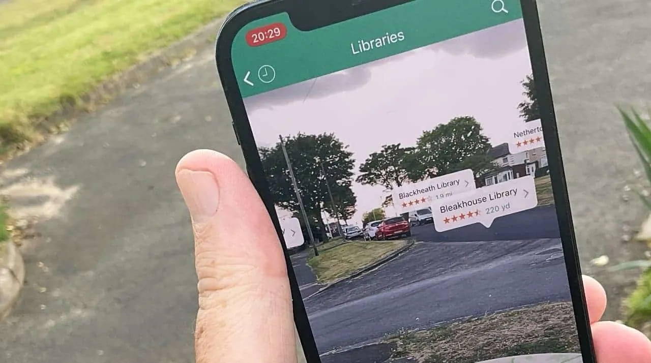
Google Lens in Maps

Google Maps now helps you understand your surroundings better when you arrive somewhere. For instance, if you're coming out of a subway station and need to figure out which way to go, or if you're exploring a new area and want to find a nearby coffee shop, Google Maps can help. Lens in Maps, which was previously called Search with Live View, uses AI and augmented reality to assist you in getting oriented quickly, whether you're navigating a new city or uncovering local treasures.
All you have to do is tap the Lens icon in the search bar, lift your phone, and you'll get information about nearby ATMs, transit stations, restaurants, coffee shops, and stores. This feature is expanding to over 50 new cities, including Austin, Las Vegas, Rome, São Paulo, and Taipei.
More Realistic Navigation Details

Google Maps is getting some new updates to make your navigation experience even better. The map will soon show more realistic buildings, which will help you get your bearings more easily, especially in busy downtown areas. On highways, you'll also get improved lane details to help you with tricky maneuvers, like changing lanes quickly to catch an exit. These updates will start rolling out in the next few months in 12 countries, including the U.S., Canada, France, and Germany.
In the U.S., Google Maps will soon inform you about the presence of HOV High Occupancy Vehicle) lanes on your route. With this feature, you can choose the best way to get to your destination. In Europe, their AI-powered speed limit information will expand to 20 countries, helping you stay safe even when speed limit signs are hard to spot on the road. Both of these features will be available on Android, iOS, and cars with Google Built-in within the coming months.
More Charging Stations Information for EV Drivers

As an electric vehicle driver, one of the things you always look out for while driving is the availability of charging stations. Being aware of where to find charging stations takes away a lot of troubles in town. This is because you know exactly where to drive to just in case you need to recharge your vehicle. This new Google Maps feature will be extremely useful for EV drivers since it will help them to find more information about charging stations with ease.
When you search for charging stations, you'll now see information about whether a charger is compatible with your specific vehicle and the charging speed (fast, medium, or slow) of available chargers. This helps you choose the most suitable charging station for your needs. Plus, since about 25% of chargers in the U.S. are often not working, Google Maps will show when a charger was last used, helping you avoid heading to one that's out of service. These updates are rolling out globally on iOS and Android wherever information about EV charging stations is available.
Additionally, Google Maps will make this EV charging information available to developers through the Google Maps Platform in the Places API. This way, companies can integrate real-time data on EV charging stations into their websites and apps, providing users with up-to-date information to plan their trips more effectively.
New Ways to Search in Google Maps
Google Maps is making your search experience more visual and inspiring. When you search for specific things like "animal latte art" or "pumpkin patch with my dog," you'll see photo-based results that match your query. These results are generated by analyzing billions of photos shared by the Google Maps community, using AI and advanced image recognition. You can scroll through the results, tap on a photo to get more details, and easily navigate to the location. This enhanced search experience is rolling out in several countries and will expand to more over time.
Additionally, when you're looking for something to do and need suggestions, Google Maps will provide better-organized search results to spark your creativity. For instance, if you're in Tokyo and search for "things to do," you'll see themed suggestions like "anime," "cherry blossoms," or "art exhibitions." You can tap on these suggestions to explore more and even save them for later. These thematic search results for activities and dining will be available globally on Android and iOS in the coming weeks.
Popular News


Latest News
Loading