Step-by-Step Tutorial: Navigating Google Maps Immersive View
GoogleTuesday, 28 November 2023 at 23:30
Google Maps is taking virtual exploration to a new level with the introduction of Immersive View, a feature that allows users to experience places as if they were there in person. Using a combination of AI and machine learning, Immersive View seamlessly blends together billions of Street View and aerial images to create a realistic and immersive representation of a location.
With Immersive View, users can virtually soar over cities, glide along rivers, and even walk inside buildings. They can also see how a place looks at different times of day and in various weather conditions. This immersive experience is designed to help users make more informed decisions about where to go and what to do.
Immersive View is currently available for a limited number of locations, but Google is expanding its reach rapidly. The company plans to make Immersive View available for more places around the world in the coming months and years.
Google Maps helps you find your way easily, with cool features like Street View, and you can even use it on your favorite Wear OS smartwatch. It's a super useful app that lets you plan your trips without stress, especially with the new Immersive View feature.
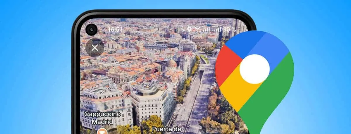
Earlier this year, Google announced Immersive View, a feature that lets you explore famous places as if you're actually there. It uses artificial intelligence (AI) to turn regular pictures of landmarks, restaurants, and popular buildings into cool 3D images. Now, Google is extending this 3D view to navigation, starting with certain cities. This guide will show you how to use Google Maps Immersive for better navigation.
Google Maps Immersive View: More Details?

Immersive View employs computer vision and AI to combine countless Street View and aerial images, forming a 3D model of the world. This provides a multi-dimensional experience, allowing you to preview bike lanes, sidewalks, intersections, and other details. Immersive View might seem similar to Google's AR maps feature, Live View, but they operate differently. Live View uses your phone's camera to assist with navigation, while Immersive View allows you to virtually soar over a location, offering insights into traffic and busyness.
One more distinction between Immersive View and Live View is Immersive View's unique capability to glimpse into the future. With a time slider feature, you can witness how a location appears at different times of the day or under various weather conditions. Beginning in November 2023, Immersive View will be accessible for driving, walking, and cycling, albeit limited to 15 cities. The featured cities include Amsterdam, Barcelona, Dublin, Florence, Las Vegas, London, Los Angeles, Miami, New York, Paris, San Francisco, San Jose, Seattle, Tokyo, and Venice.
Steps in Using Immersive View in Google Maps

Exploring new locations with Immersive View in Google Maps is possible, but currently limited to the 15 supported cities. The feature is available on both Android and iOS devices. This tutorial uses an Android phone for demonstration.
- Open Google Maps on your Android or iOS device.
- Tap the search bar located at the top.
- Enter the name of a landmark in one of the 15 supported cities. For instance, you can search for the Eiffel Tower.
- In the search results, you'll see an Immersive View card. Tap on this card from the pop-up menu at the bottom of the screen.
- Once you tap the Immersive View card, you can explore the location just like you normally do on Google Maps and Street View. Swipe, pinch, and zoom to navigate around the area and get a 3D view of the surroundings.
- To explore further, tap the Time & Weather icon at the bottom. This allows you to see how the location looks at different times of the day and provides the weather forecast for the next few days. You can scroll left and right on the slider at the bottom to observe how the scenery changes with varying weather conditions throughout the day.
Immersive View also allows you to tour the inside of certain establishments, although this feature is available in only a few locations. When you're inside a building, you'll have a joystick for navigation. Simply pull it up or down to move forward or backward within the space.
Using Google Maps Immersive View in Driving

Google Maps' Immersive View lets you see your route before you start your journey. It includes details like bike lanes, sidewalks, intersections, and parking. This feature works for driving, walking, and biking directions. It even informs you about expected traffic conditions at different times of the day.
Google has begun introducing Immersive View to the 15 supported cities, but it might not be accessible to everyone just yet. The release is expected to occur gradually, so certain users may get access to the feature earlier than others.
- Open Google Maps on your Android or iOS device.
- Enter your destination in the search bar at the top.
- Choose your destination from the search results and tap on "Directions" in the lower-left corner.
- Select your mode of transportation (Driving, riding or walking)
- If the Immersive View feature is available, you will see a button to launch it. Preview every step of your journey by tapping the button. The preview may take a moment to load because it's streamed from the cloud. If you don't see a button, check again later as the feature may not be available for your location or it's still being rolled out.
Conclusion
Immersive View is a useful feature that can simplify navigation, especially for planning trips or exploring new places virtually. However, its limited availability is disappointing. An alternative is Google Street View, which is a reliable option and is accessible in more locations.
If you require a precise view of a location, you can turn to satellite imagery on Google Maps as an alternative. Additionally, you have the option to download Google Maps offline for use in areas without an internet connection. For more in-depth geo-imaging, Google Earth Pro is available, offering a comprehensive compilation of satellite data in one system.
Popular News


Latest News
Loading